Brian Brenner, P.E., F.ASCE, is a professor of the practice at Tufts University and a principal engineer with Tighe & Bond in Westwood, Massachusetts. His collections of essays, Don’t Throw This Away!, Bridginess, and Too Much Information, were published by ASCE Press and are available in the ASCE Library.
In his Civil Engineering Source series More Water Under the Bridge, Brenner shares some thoughts each month about life as a civil engineer, considering bridge engineering from a unique, often comical point of view.
This month’s entry serves as a review of ASCE Fellow Jerry A. Cannon's book “The Navajo Bridge: Challenging Nature’s Barriers to Transportation,” published last year by Vishnu Temple Press, Flagstaff, Arizona. The first Navajo Bridge (1929) is a National Historic Civil Engineering Landmark.
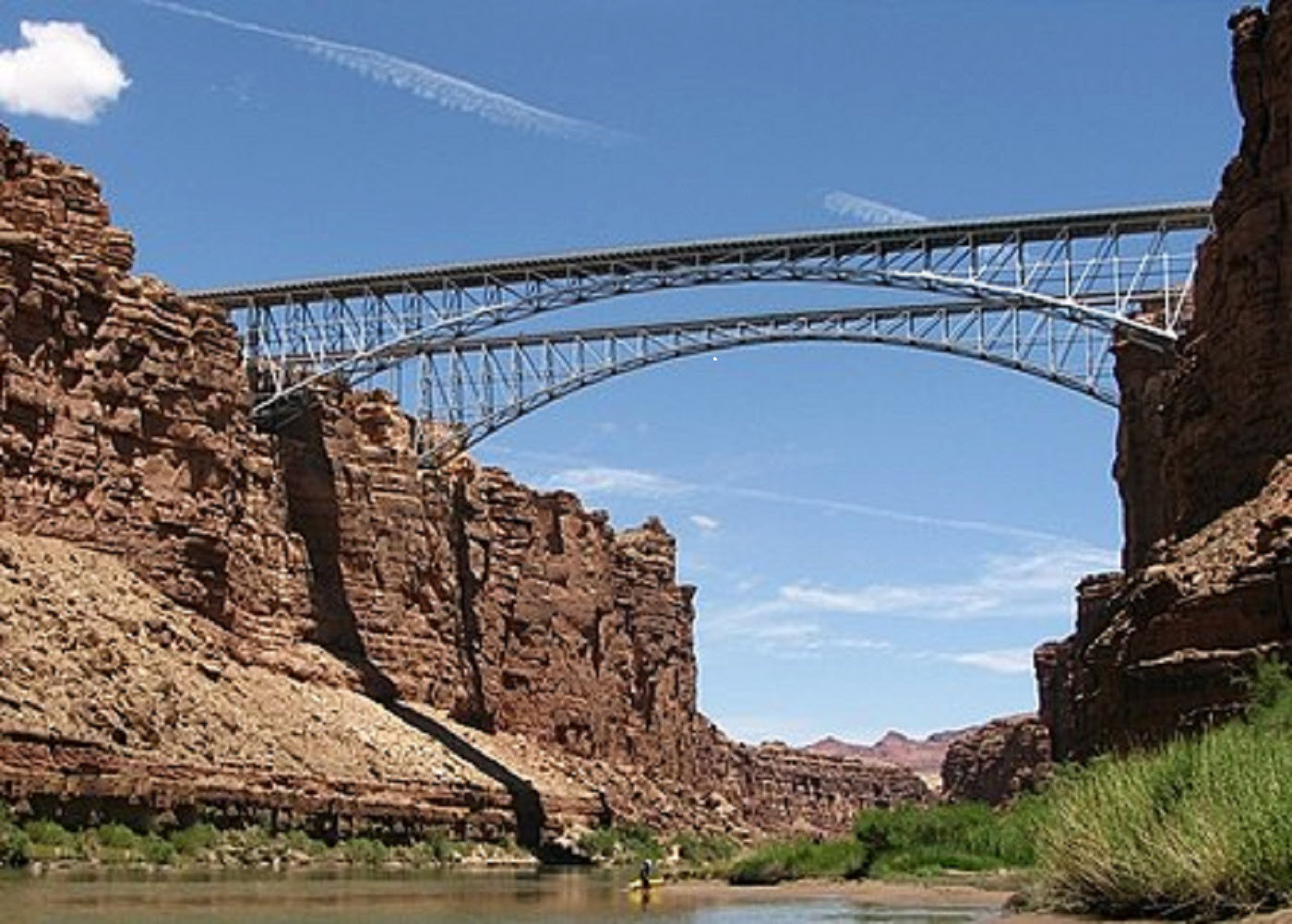
Driving north in the desert from Flagstaff to Page on Arizona US Highway 89, there is a turnoff onto Highway 89A, with a mirage. In the distance, a vision of twin shimmering steel arch bridges crosses a deep gash in the surrounding desert scrubland. Closer in, the vision turns out to be reality: two classic, slender deck truss arch bridges spanning 800 feet or so across Marble Canyon. The free-flowing Colorado River continues south under the twin bridges into the deeper and wider Grand Canyon.
The overall crossing is referred to as the Navajo Bridge, but it is two bridges: the original span constructed in 1927-1928, and a more modern crossing built in 1993-1995. The chief engineer of the second span, Jerry Cannon, P.E., F.ASCE, wrote a book, “The Navajo Bridge: Challenging Nature’s Barriers to Transportation.” It describes the design and construction of the two bridges.
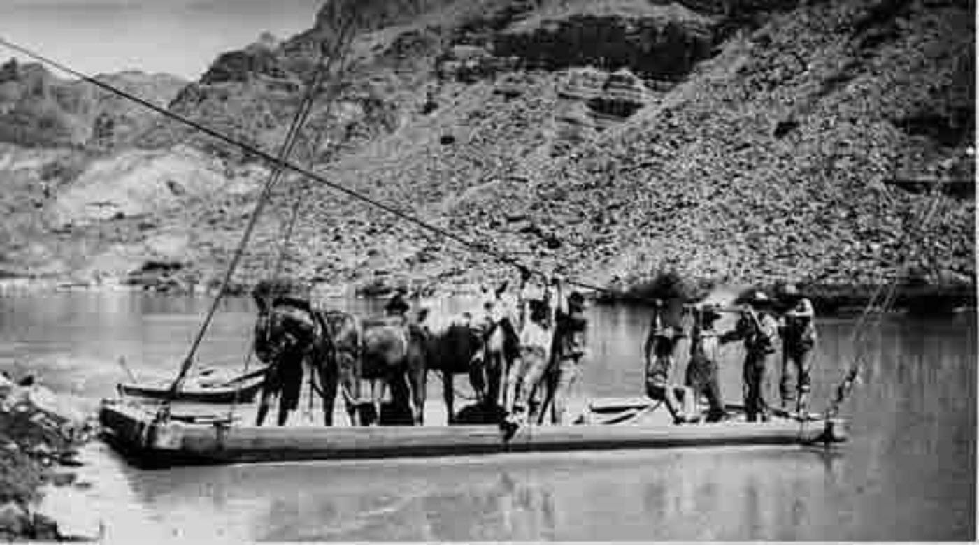
Before construction of the first bridge, travelers could cross the river at Lee’s Ferry. The crossing consisted of a cable strung across the river which was used to guide a wood-planked barge. Travelers would descend to the river and climb back up on narrow roads hewn into the canyon walls. Cannon describes how the ferry was fragile and hazardous, with floods frequently washing out the cable, along with travelers on the barge.
In the 1920s, proposals were made to construct a fixed river crossing. The proposals were prompted by the newly developing tourist economy with establishing the Grand Canyon National Park and other parks in southern Utah. Some bridge funding was provided from a questionable application of a Navajo Nation fund. This fund was established to support the Navajo people. Its use for a new bridge was justified as a way of promoting Navajo Nation welfare and development. In reality, the new bridge was largely a boon for the new tourists and burgeoning immigrant population and not so much for the Navajo residents.
Cannon describes political developments for procuring funds and the start of design and construction. A bridge alternatives analysis settled on a compression deck arch that would span the canyon walls. The book includes some interesting original drawings. Unfortunately, no discussion is provided about how the 1920s analysis and design were performed for a structure that was sophisticated for its day. Today’s bridge engineers, familiar with almost instant 3D analysis and realistic computer renderings, would have enjoyed a description of how it was done back in the day. The painstaking process did not benefit from AutoCAD but relied on hand drawings and overheated slide rules.
Bridge parts were fabricated and shipped by rail to Flagstaff, 120 miles to the south. A haul road was constructed to the Marble Canyon site north across the remote plateau. A small tent camp was established at the halfway point so that drivers could change trucks and rest. The lonely camp had a few sleeping tents and a food station. Cannon describes its Wild West feel. Constructors and engineers would camp out in the remote, wind-swept desert.
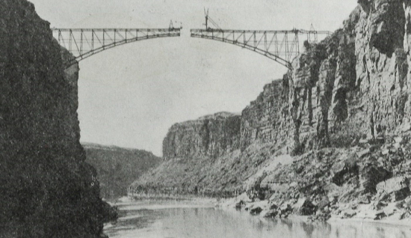
Bridge construction started in 1927. Dynamite was used to excavate notches into the canyon walls. To save money on the construction contract, Arizona Highway Department staff constructed the foundations. Overall, the work in 1927 was governed by a few state and national environmental regulations. This project aspect is startling to read about, especially in comparison to the requirements for the second bridge.
Cannon provides interesting descriptions of the challenging construction work, and it is well-documented in the book. The truss sections of the arch were extended out from canyon walls to meet in the center. For closing the span in July 1928, both sides had toggles to raise the constructed half arches to ease them into position for the closing pieces. The two sections were lowered into place and connected by pins on Sept 12, 1928. Then the deck was poured, and in January 1929, the new bridge was open to traffic.
The bridge was officially dedicated on June 14-15, 1929. Temporary facilities were built to accommodate thousands of guests for the ceremony. Although tourists were then flocking to the Arizona Canyons during the period just before the Great Depression, there were few facilities at Marble Canyon to support the crowds. A plaque along the bridge approaches proudly declared the opening of the “Grand Canyon Bridge.” This short-lived name indicated a controversy that was finally resolved in 1934 when the National Park Service changed the name to the “Navajo Bridge.”
The bridge was a success, but over time its features became dated. Truck weights increased. The original design was for a 27-ton truck with an axle weighing 10 tons. In 1957, a structural analysis determined that the main span was OK, but approach spans on both sides were overstressed. The recommendations included placing new columns at the approach spans to reduce overall span length, as well as posting the bridge for limited loads and reducing the speed limit. However, these were short-term remedies as truck sizes and weights increased. In 1959, a new arch bridge was constructed 12 miles north of the site near the Glen Canyon Dam. This provided an alternate route and reduced traffic demand on the Navajo Bridge.
In addition to structural limitations, the Navajo Bridge was only 18 feet wide, with two narrow travel lanes and no shoulders or sidewalks. This was barely enough for two trucks to pass. In 1984, the bridge was classified by the Arizona Department of Transportation as substandard. Funding was scheduled for a project to widen and strengthen the bridge.
ADOT released a contract to study options and evaluate conceptual designs. The author’s firm, Cannon & Associates, was shortlisted along with Greiner and Parsons Transportation Group (using a local name of Hoffman-Miller, previously involved with the first bridge). Cannon & Associates added sub-consultants Parsons Brinckerhoff (now WSP) and others to their team to bolster technical capabilities, including expertise with permitting, which was a major addition to the scope compared to the original project. Cannon was a smaller Arizona bridge firm and was a bit of an underdog compared to the other finalists, which were larger, national AE firms. However, buoyed by their local expertise, impressive presentations, and proposals, Cannon won the job. NTP was founded in October 1986.
The author describes how bridge options gradually shifted from widening and strengthening of the existing bridge to constructing a new bridge downstream. The existing bridge was to be preserved for pedestrians. Along the way, readers are treated to a discussion of the evolving bridge design process, especially the consideration of modern requirements for permitting and environmental review. The project was unusual in that the new bridge was designed and built at the same location with many of the same constraints but following decades after constructing the first span.
Cannon insisted that the new, modern bridge not detract from the existing historic span. He writes:
“The new bridge would not copy the technical design of the historic bridge but would be comparable in type, scale, proportion, and materials. It would be a steel deck truss arch, contemporary in design. We sought visual harmony for the closely spaced structures. Visual harmony is not a typical design goal of bridge engineers, but we felt it appropriate for this project; the new bridge would soar across Marble Canyon beside Ralph Hoffman’s iconic bridge, considered by many to be Arizona’s most aesthetically successful example of civil engineering.”
The innovative idea of “visual harmony” was not often considered in comparable projects where a new bridge is built adjacent to an existing span. Cannon describes several details, such as battering the vertical arch columns and braces and perforating steel members. These details helped the new bridge look like the old bridge but were not necessarily needed for the design. The site and mass of the new bridge were also important to achieve harmony. Says Cannon:
“Determining the location of the second bridge was the single most important design decision. Letting the bridge rather than the roadway control project location and design was an innovative approach. Because the second bridge is parallel to and at the same elevation of the first bridge, the two bridges look like they were always meant to be together at this site.”
Fortunately, Cannon’s design visually respected elements of the older bridge, even as the new bridge was updated to modern design criteria and materials. The resulting crossing is a pair of deck arches that harmonize as they soar across Marble Canyon. They almost look like twins that are not separated by decades.
“The Navajo Bridge” is a great read for bridge engineers and anyone interested in northern Arizona history. It has lots of nuts-and-bolts discussion, but it is not overly technical, so it is also approachable for general readers. The book is well-illustrated with historical photos, bridge construction pictures, and illustrations of design plans and construction methods. The author does a terrific job of describing the process of honoring the old bridge by focusing on the look and feel of the new one. Today both bridges are spectacular spans at a spectacular site.